We’ve been pretty busy polishing up the new Garmin Push API, but we still made a little time to add some small but helpful features.
Projected finish time
If you’ve ever run a marathon, you’ve probably wondered: “If I had run the second half as fast as my first half, what would my time have been?”
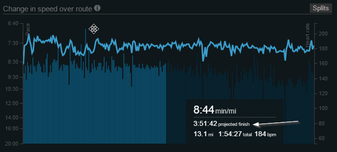
Well, now you can. Just highlight a section of your pace graph on the bottom of your By Run page. And, of course, you can do the same for any segment of any distance run.
Stryd power meter support
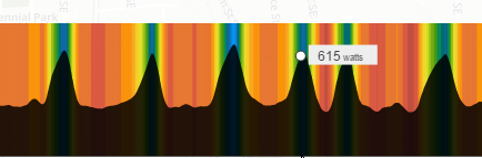
We’re now importing running power from the Stryd power meter. Power meters are cool because they tell you how much energy you’re using instead of how fast you’re running. If you run faster but your power goes down, that means that you’re running more efficiently, and improving running efficiency is how you can see some of the biggest gains in performance. Power meters are also cool for trail runners, because they are unaffected by hills. Top athletes run fast down hills and slow up hills, but their power and heart rate stay mostly flat.
Elevation Correction
We’ve added an option to correct the elevation for runs where the elevation looks a bit (or a lot) wonky. The data available for this correction comes from satellite topography, so the resolution is not wonderful. If you run over a bridge, it’ll show you running across the river. If you run through a tunnel, it’ll show you running up and over the top of the tunnel. GPS-based elevation data is, in general, pretty terrible and only a few lucky people have barometric altimeters (woop iPhone 7!), so there’s a lot of messed up elevation data out there. Using this option can be a big improvement.
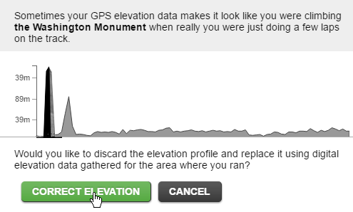
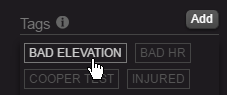
After correcting the elevation, you can also click the bad elevation tag again to remove the elevation data.
Great job! Thank you 😉 One question:
After correcting the elevation, is it possible to turn the correction off again and go back to original recorded elevation data (e.g. SportTracks.mobi-style)?
Right now it’s an overwrite, so the only way to go back is to reimport with a file. We considered keeping the redundant copy of old elevations, for undo purposes, but we figured it would mostly go unused and just consume space. Fighting to keep the run record as lean as possible, without resampling.
Any advice on how to make sure power from Stryd is picked up? I sync my runs to SmashRun via tapiriik, with the files typically loaded up into SportTracks.mobi as a first step. (Either from Polar Flow, or the combined GPS/power meter FIT files from Stryd.) I’m not seeing any power on the map view though?
I don’t think it’ll be picked up via Tapiriik since it’s not pushing files in the original format. We can only read it from Garmin FIT files, so it’s best to connect to the Garmin Auto-Sync. Will email you as well!
Stryd-Power is shown to me – great improvement!!!
i use the sync-button in smashrun to import runs from garmin.
I dont use tapiriik for that.
I am syncing by using the sync button, but I am not seeing my Stryd Power meter data.
What should I change with my setup?
fwiw, Nexus phones have had a barometer since 2011 and your partner app Ghostracer has supported it as an activity sensor as long as I can remember 🙂
https://plus.google.com/communities/108600094791246159447/